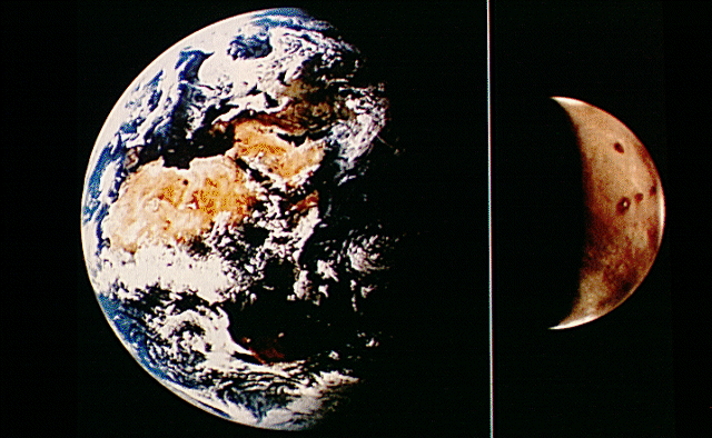
 1. Earth-Mars Comparison
Introduction
This slide set was chosen to show some of the best examples of volcanic landforms on Mars, visible in images returned by the two Viking Orbiter spacecraft. The set of 20 slides cannot provide an exhaustive treatment of volcanism on Mars, but it should serve as an overview to the subject. For a more detailed description of the various interpretations proposed for individual volcanoes on Mars, please refer to the list of references provided at the end.
1. Earth-Mars Comparison
Mars is only about one-half of the size of Earth and yet the red planet has several volcanoes that surpass the scale of the largest terrestrial volcanoes. The four brown spots visible on the northern (upper) portion of the planet are four enormous volcanoes on the Tharsis region of Mars. Olympus Mons (slides #2 and #3) is the northernmost volcano and the three aligned volcanoes are the Tharsis Montes (slide #4). This view emphasizes the fact that the volcanoes of Mars are significant not only as localized centers of eruptive activity but also as prominent landforms on a planetary scale. (Viking Orbiter Views of Mars, NASA SP-441, p. 14, U.S. Govt. Printing Office, Washington, DC.)
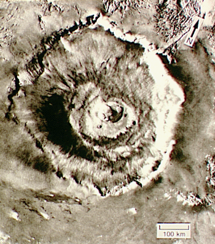 2. Olympus Mons
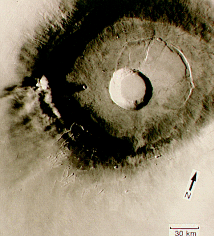
This mountain is the largest of the four Tharsis volcanoes. Spanning approximately 500 km (300 mi) horizontally and rising over 24 km (14.4 mi) above the surrounding plains, Olympus Mons is one of the largest volcanic constructs in the solar system. The volcano is so large that an accurate representation of the shape of the mountain must include the curvature of the planet’s surface. The average slope of the flanks of the volcano is about 5º (from horizontal), similar to terrestrial shield volcanoes. The summit of the volcano consists of a group of nested, quasicircular depressions; these depressions are very similar to calderas present at the summits of terrestrial shield volcanoes. Calderas on shield volcanoes are primarily the result of collapse, presumably related to the withdrawal of magma from the interior of the construct, rather than the direct result of explosive removal of summit material. Olympus Mons is surrounded by a scarp 3 to 6 km (1.8 to 3.6 mi) high that is unique among the martian volcanoes. (18 N, 133 W; Viking Orbiter frame 646A28; shading corrected version.)
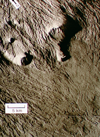 3. Olympus Mons Flows
Individual lava flows can be traced from the lower flanks of Olympus Mons over the southern basal scarp of the volcano and onto the surrounding plains. Several flows display well-developed leveed channels that fed the molten rock to the advancing flow front. The overall dimensions of these flows are comparable to but often larger than the dimensions of individual basalt flows on terrestrial shield volcanoes, such as those that make up the Hawaiian Islands. (14 N, 134 W; Viking Orbiter frames 468S37 and 39, shading corrected version.)
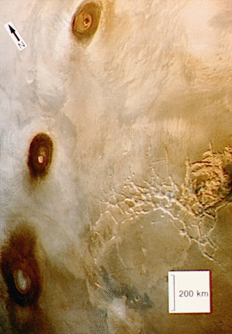 4. Tharsis Montes
The alignment of the three shield volcanoes that make up the Tharsis Montes is clearly evident in this view. The three volcanoes are named Ascraeus Mons (slides #5 and #6), Pavonis Mons (slide #7), and Arsia Mons (slide #8), going from north to south. The three volcanoes are each somewhat smaller than Olympus Mons, varying from 350 to 450 km (210 to 270 mi) in horizontal extent and each rising about 15 km (9 mi) above the surrounding plains. The Tharsis Montes are located on the crest of a broad uplift of the martian crust so that their summits are at about the same elevation as the summit of Olympus Mons. The fractures southeast of Pavonis Mons are named Noctis Labyrinthus; this region merges with the enormous Valles Marineris canyon system to the east. The colors shown here are similar to the actual color of Mars but have been enhanced to emphasize subtle variations. The white patches around the lower flanks of the volcanoes are thin clouds that commonly occur near the volcanoes (0 N, 100 W; portion of a color digital mosaic generated by Al McEwen at U.S. Geological Survey, Flagstaff, AZ.)
 5. Ascraeus Mons Summit
The images used to make this mosaic have been computer processed to emphasize surface relief and reduce the variations in surface reflectance (albedo). The complex caldera is composed of several discrete centers of collapse where the older collapse features are cross-cut by more recent collapse events. The lowermost circular floor preserves the last lava flooding event that followed the last major collapse. The southern wall of the caldera has at least 3 km (2 mi) of vertical relief with an average slope of at least 26º (from horizontal). The caldera complex truncates several lava flows, indicating that the flows predate the collapse event and that their source areas have been destroyed by the caldera formation. The arrow indicates the lava flow shown in slide #6. (11 N, 104 W; digital mosaic of Viking Orbiter frames 401B16 to 24, high-pass spatially filtered version, generated by Jim Zimbelman at LPI, Houston, TX.)
 6. Ascraeus Mons Flows
This slide shows a close-up view of only a portion of the mosaic shown in slide #5. The leveed lava flow at the center of the slide is comparable in overall dimensions to the 1984 lava flow on Mauna Loa in Hawaii. Like terrestrial shield volcanoes, the martian shield volcanoes appear to be the product of thousands of individual lava flows. (10 N, 105 W; portion of Viking Orbiter frame 401B16, high-pass spatially filtered version.)
 7. Pavonis Mons
The circular caldera portrays only a single collapse event, in contrast to the complex caldera on Ascraeus Mons (slide #5), but it is possible that smaller collapses preceded the last event and were completely eliminated during the formation of the present caldera. A large portion of the summit of Pavonis Mons has undergone subsidence that did not result in the formation of a caldera; the ridge to the northeast of the caldera marks the edge of the zone of subsidence. The small white features west of the caldera have been interpreted to be dust clouds generated by relatively strong winds blowing downslope on the volcano. (0 N, 113 W; Viking Orbiter frame 358S59, shading corrected version.)
 8. Arsia Mons
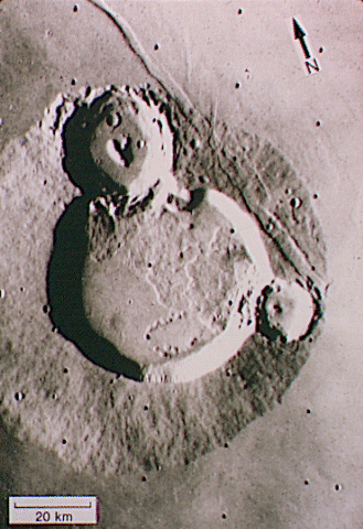
The caldera on Arsia Mons is considerably larger than the calderas on either Ascraeus Mons (slide #5) or Pavonis Mons (slide #7). However, the last major collapse event on Arsia Mons was followed by substantial outpouring of lava within the caldera. The caldera rim has been breached on the southwest side while the caldera floor lavas bury portions of the northeast rim. Aligned between these breaks in the caldera is a series of very subdued domes on the caldera floor (arrow), perhaps representing localized sources of the lava that flooded the caldera. The flanks of the shield have been deeply eroded near the locations of the breaks in the caldera rim and lava flows extend away from the volcanoes at these embayments. It is significant that the trend indicated by the subdued domes and the shield embayments is colinear with the three Tharsis Montes volcanoes, indicating that this trend is important for the entire Tharsis Montes region. (9 S, 120 W; Viking Orbiter frame 62A36, shading corrected version.)
 9. Alba Patera
This volcano is comparable to Olympus Mons in horizontal extent but not in vertical relief; recent topographic maps show a total vertical relief of less than 7 km (4.2 mi) for Alba Patera. Just as the basal scarp is unique to Olympus Mons, Alba Patera is surrounded by a distinctive set of enormous fractures having a predominantly north-south orientation. The fractures have apparently been diverted around the central part of the Alba Patera complex. The low relief of Alba Patera may be due to the collapse of a structure comparable to the Olympus Mons shield but there is no direct evidence that such a collapse actually occurred. An alternative explanation for the low relief is that Alba Patera may include a significant portion of pyroclastic materials (ash) from its early history, caused by eruptions that are more explosive in nature than those typically associated with the effusion of lava flows. Alba Patera is older than the shield volcanoes in the Tharsis region and may represent a change in the style of centralized volcanic eruptions on Mars. The arrow indicates the lava flows shown in slide #10. (40 N, 110 W; Viking Orbiter frames 783A11 to 16, high-pass spatially filtered orthographic version.)
 10. Alba Patera Flows
The lava flows shown here are substantially larger than the individual flows visible on the shield volcanoes (slides #3 and #6); shadow lengths indicated flow thicknesses in excess of 50 m (164 ft) at many places. The flows have a smooth upper surface (at the resolution of these images) and they lack the leveed central channel common on many of the shield volcano flows. The plains over which the flows have been emplaced include areas that appear to be etched by some flowing liquid (see arrow). It is possible that the eroding liquid was water, perhaps released from the ground by the heat of the lava flows. (46 N, 115 W; Viking Orbiter frames 252S01, 3, 5, 32, 34, and 36, high-pass spatially filtered orthographic version.)
 11. Ulysses Patera
This feature is an example of a class of volcanoes that are considerably smaller than either the broad shield volcanoes or Alba Patera. The summit consists of a single, very circular caldera with a smooth floor that predates the ejecta from two large impact craters. The lower flanks of the volcano, including portions of the impact craters, have been buried by the material that makes up the surrounding plains. This superpositional relationship indicates that the plains were emplaced subsequent to both the volcano and large impact craters on the volcano. The plains are probably made up of lava supplied from the Tharsis Montes that flowed down the sides of the broad uplift associated with the Tharsis shields. Both the plains and the volcano are cut by a graben (a paired set of linear faults), indicating tectonic activity subsequent to the emplacement of the plains. (3 N, 121 W; Viking Orbiter frame 49B85, shading corrected version.)
 12. Biblis Patera
Located close to Ulysses Patera (slide #11), the lower flanks of Biblis Patera have also been buried by the plains that surround the Tharsis Montes. The northwestern flank of Biblis Patera (extending left from the summit caldera) is less covered by the plans because it is on the downslope side of the uplift associated with the Tharsis Montes and the lavas flowed around Biblis Patera. The summit caldera is circular in outline but multiple collapse events are indicated by the interior morphology of the caldera. (2 N, 124 W; Viking Orbiter frame 44B50, high-pass spatially filtered version.)
 13. Ceraunius Tholus
A prolonged eruptive history can be inferred from the stratigraphic relationships evident on this volcano. The lower flanks of the volcano have been buried beneath the plains material, as was the case with both Ulysses (slide #11) and Biblis (slide #12) Paterae, but a major impact crater postdates both the volcano and the plains in the upper portion of the frame. However, a prominent delta of probable volcanic material was emplaced within the impact crater (see arrow) at the mouth of a sinuous channel that extends up the flank of the volcano to the summit crater. A smaller sinuous channel on the western (left) flank of the volcano also appears to have a subtle delta of material that may overlay the plains. (24 N, 97 W; Viking Orbiter frame 516A24, shading corrected version.)
 14. Elysium Mons
This volcano sits on the top of an uplifted portion of the martian crust, similar to but not much smaller than the uplift associated with the Tharsis volcanoes (slides #2 through #13). The flanks of Elysium Mons are steeper (about 10º) than the flanks of the shield volcanoes so that Elysium Mons may consist of volcanic materials more chemically evolved than the fluid lavas associated with the Tharsis Montes. A single, very circular caldera is present at the summit of the volcano. Several large channels have their origin northwest of the volcano, perhaps carved by flowing mud and water released by the heat associated with the Elysium volcanism. (15 N, 213 W; Viking Orbiter frames 541A41 to 46, high-pass spatially filtered orthographic version.)
 15. Hecates Tholus
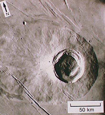
Located northeast of Elysium Mons (slide #14), Hecates Tholus is comparable in size to Elysium Mons and is close to the crest of the regional crustal uplift. Several collapse events are recorded within the caldera complex and the caldera rim has been breached by at least two sinuous channels. The flanks of the volcano have a rather dense cover of craters, indicative of a considerable age for the volcano, except in a region to the west of the summit caldera (see arrow). The sparsity of craters in this region has been interpreted to be the result of burial by pyroclastic materials (ash) erupted explosively from the summit area. (33 N, 210 W; Viking Orbiter frame 651A19, shading corrected version.)
 16. Apollinaris Patera
This volcano is located about 2700 km (1600 mi) southeast of Elysium Mons near the boundary between the densely cratered plains of the northern hemisphere. The southern flank is covered by a radiating fan of lava flows emanating from a breach in the southeastern rim of the caldera. Different episodes of caldera flooding are preserved as floor segments within the caldera. The lowest caldera floor is probably contemporaneous with the lava flows covering the southern flank. (8 S, 186 W; portion of the MC23NE subquadrangle photomosaic generated by the U.S. Geological Survey, Flagstaff, AZ.)
 17. Tyrrhena Patera
Volcanoes located within the densely cratered southern highlands have a very different morphology from either the Tharsis or Elysium volcanoes. Tyrrhena Patera has very little vertical relief (less than 2 km, or 1.2 mi), resulting in very shallow flank slopes. The flanks of the volcano are deeply eroded with many broad channels that radiate from the summit region. The low relief and easily erodible nature of the flank materials has been interpreted to indicate that the bulk of the volcano is composed of pyroclastic (ash) deposits. This interpretation implies that the style of eruption for the highland volcanoes like Tyrrhena Patera is significantly different from the repeated effusion of fluid lavas that built up the shield volcanoes. (22 S, 253 W; Viking Orbiter frame 87A14, high-pass spatially filtered version.)
 18. Hadriaca Patera
Much like Tyrrhena Patera (slide #17), Hadriaca Patera is a deeply eroded feature having little vertical relief. Several impact craters are superimposed on the eroded flanks, indicating a great age for this volcano. A large channel has its source near the southeastern margin of the volcano; the fluid that carved the channel flowed southwest into the interior of the Hellas basin. (30 S, 267 W; Viking Orbiter frame 106A09, shading corrected version.)
 19. Tempe Volcano
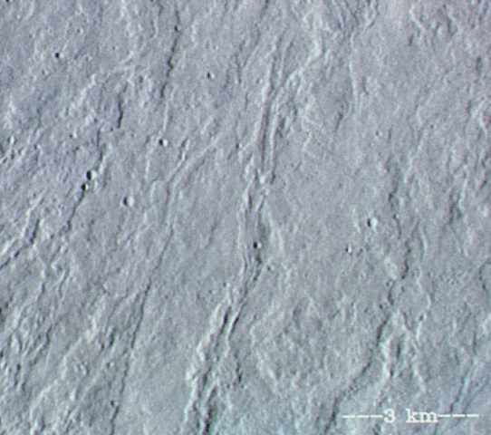
Volcanic constructs on Mars are not all enormous mountains like Tharsis Montes. The elongate hill surmounted by a linear depression (see arrows) is interpreted to be a product of localized but not extremely voluminous eruptions. If the volcanic material was emplaced by ejection along a ballistic trajectory, this feature may be similar to a terrestrial cinder cone. This feature is aligned with several grabens in the area so that a structural weakness in the crust may have provided the conduit for the volcanic material to reach the surface. (36 N, 86 W; portion of Viking Orbiter frame 627A28, shading corrected version.)
 20. Hellas Mounds
Numerous small mounds having summit craters are found in various locutions on Mars. The mounds shown here are east of the Hellas basin. These features have been interpreted to be pseudocraters created by localized phreatic (steam-related) explosions where lava interacts with volatile-rich ground. However, images presently available do not have sufficient resolution to show conclusive evidence of a volcanic origin for the mounds. (43 S, 239 W; portion of Viking Orbiter frame 586B34, high-pass spatially filtered version.)
Definitions provided here are summarized from Bates and Jackson (1987).
Albedo - The ratio of the amount of light reflected by a surface to the amount of light incident upon it.
Ash - Fine-grained material produced by a pyroclastic eruption. An ash particle is defined to have a diameter of less than 2 mm. See pyroclastic.
Basalt - A general term for dark-colored igneous rocks composed of minerals that are relatively rich in iron and magnesium.
Caldera - A large, basin-shaped volcanic depression that is more or less circular in form. Most calderas are produced by collapse of the roof of a magma chamber due to removal of magma by voluminous eruptions or subterranean withdrawal of the magma, although some calderas may be formed by explosive removal of the upper part of a volcano. See magma.
Cinder cone - A conical hill formed by the accumulation of pyroclastic fragments that fall to the ground in an essentially solid condition. See pyroclastic.
Eruption - The ejection of volcanic materials (lavas, pyroclasts, and volcanic gases) onto the surface, either from a central vent or from a fissure or group of fissures. See lava, pyroclastic.
Graben - An elongate, relatively depressed crustal unit or block that is bounded by faults on its long sides.
Igneous - Used to describe a rock or mineral that solidified from molten or partly molten material, i.e., from a magma. See magma.
Lava - A general term for molten rock that is extruded onto the surface.
Magma - Molten rock within the crust of a planet that is capable of intrusion into adjacent crustal rocks or extrusion onto the surface. Igneous rocks are derived from magma through solidification and related processes or through eruption of the magma at the surface. See igneous.
Phreatic eruption - A volcanic eruption or explosion of steam, mud, or other material that is not incandescent. This form of eruption is caused by the heating and consequent expansion of ground water due to an adjacent igneous heat source. See igneous.
Pseudocrater - A generally circular crater produced by a phreatic eruption resulting from emplacement of a lava flow over wet ground. See phreatic eruption.
Pyroclastic - Pertaining to a clastic (broken and fragmented) rock material formed by volcanic explosion or aerial expulsion from a volcanic vent.
Scarp - A relatively straight, clifflike face or slope of considerable linear extent, breaking the general continuity of the land by separating surfaces lying at different levels.
Shield volcano - A volcano in the shape of a flattened dome, broad and low, built by flows of very fluid lava.
Volcano - A vent in the planetary surface through which magma and associated gases and ash erupt; also, the form or structure produced by the erupted materials. See ash, eruption, magma.
Bates R. L and Jackson J. A., eds. (1987) Glossary of Geology, 3rd edition, American Geological Institute, Alexandria, VA. 788 pp.
Carr M. H. (1975) The volcanoes of Mars. Scientific American, 234, 32-43.
Carr M. H. (1981) The Surface of Mars. Yale University Press, New Haven. (See Chapter 7, pp. 87-113.)
Greeley R. and Spudis P. D. (1981) Volcanism on Mars. Reviews of Geophysics and Space Physics, 19, 13-43.
Mutch T. A., Arvidson R. E., Head J. W. III, Jones K. L., and Saunders R. S. (1976) The Geology of Mars. Princeton University Press, Princeton. (See Chapter 5, pp. 151-201.)